如何去傲慢与偏见的拍摄地Peak National Park
2024-11-09 19:30游四海旅游网 帮助了6111人
想去看傲慢与偏见里女主角站在悬崖上的拍摄地, 听说那个镜头是在那里拍的,不知道有没有人去过
网友回答
这几个地方我都去过,也都是公交来的。只是当时懒得写了,现在就有点忘记了。
从chatsworth的网站http://www.chatsworth.org/finding-us里的公共交通哪里是可以查到一些的。
去悬崖那段如楼上同学所说,是要hiking的。
当时做的功课太乱了,现在都搞不清楚了,且传一些大家看看吧。
Stanage Edge, Peak District, DerbyshireClick here for Walkingworld's step-by-step guide with maps
The Guardian, Saturday 20 May 2006
Article history
Stanage Edge, Peak District, Derbyshire
Classification Moderate walk
Distance 7.8 miles (12.5km)
Typical duration 4 hours
Height gain 400m
Starting point Cattisside Moor car park, near Hathersage
OS grid reference SK 245 828 (Explorer map OL 1)
Walk in a nutshell
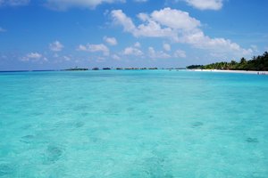
An opportunity for walkers of average fitness to experience the eclectic delights of the Peak District - and briefly pretend to be Keira Knightley in Pride and Prejudice, gazing out for miles and miles from wonderful Stanage Edge. After a short climb, the first half of the walk takes you along this bleak and rocky terrain, before dropping down over Stanage Moor into the contrasting green fields and woodland of the valley north of Hathersage. It follows mainly paths and good tracks, with a small amount of (quiet) road-walking.
Why it's so special
You get two walks for the price of one, so to speak. Once you've had your fill of the breathtaking, ever-changing views over the Dark Peak, the second half of the walk reveals the sheer expanse and beauty of the Derbyshire countryside (Jane Austen herself wrote that there's "no finer county in England").
Keep your eyes peeled for
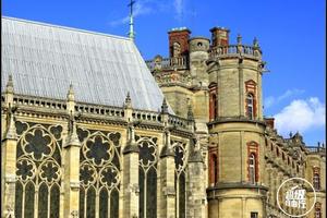
Filming for the latest adaptation of Pride and Prejudice also took place at North Lees Hall, a lonely and romantic Elizabethan tower house you pass on your way back from Stanage Edge. The hall was also featured (as Thornfield Hall) in Charlotte Bronte's novel Jane Eyre.
But bear in mind
The paths can be muddy so walking boots are essential, gaiters recommended. And dog owners beware: parts of this walk are not on public footpaths so it's possible dogs may not be permitted on these sections.
Impress your companions
Jane Austen's original title for Pride and Prejudice was First Impressions. At the very beginning of the 2005 film version, Knightley's character Elizabeth is shown reading a novel with that title.
Recover afterwards
The Peacock, in the small village of Stannington, offers traditional pub food and a selection of beers and real ales. Food served 12-7pm.
And if it's tipping down
Just up the road, Sheffield provides a perfect plan-B. From shopping to museums and galleries, the choice is wide - although the Millennium Galleries, famed for bringing blockbuster art exhibitions to the city, is the jewel in the crown. Open 10am-5pm (11am start on Sundays).
How to get there
By car Aim for car park near Cattisside Moor (grid ref 245 828). From A625 travelling through Hathersage from Sheffield direction, take first right (signposted to school). Climb out of Hathersage, car park is at left turn after 1.5 miles.
By train The nearest station is in Hathersage.
1-2. From car park near Cattisside Moor (grid ref 245 828), follow either of two paths uphill towards Stanage Edge. They converge after 50 yards. Turn left along Stanage Edge, ignoring any paths leading back downhill.
3. After about 3-4 miles, once Ladybower Reservoir has become visible to west and A57 to north, a wide path leads slightly downhill towards milestone marked "WW" (this turning is obvious). Almost immediately, turn hard left and walk back along bottom of Stanage Edge. In about 100 yards path becomes indistinct for a short distance, but it is easily picked up again.
4-6. After about 2½ miles, path passes through area littered with millstones. Soon after, take another path to right, heading downhill towards stile and small coppice beyond. Cross stile, cross track and follow path along left-hand side of coppice for 1/3 mile. Path leads across grassy area to cattle grid in road. Cross cattle grid.
7-9. Turn right along path which follows left side of wood. After 1/3 mile path bears right, leading to stile over wall (Dennis Knoll on right). Cross stile and carry on ahead, ignoring footpath on left. Path passes through gap in wall, before heading downhill to gate. Once through gate, turn left and pass between two farm buildings.
10-13. In a few yards (just by gate after garden on right), follow narrow path on right beside garden. Follow into open fields, crossing several stiles. Within 3/4 mile woodland is reached. Follow path into woods. Cross footbridge and follow path ¼ mile, keeping stream on right. Cross stile on to road and turn left, passing Bronte Cottage on left.
14-16. In 100 yards, take metalled track on left, uphill towards North Lees. This track turns into rough track and turns uphill behind house. By sign explaining history of North Lees House, stone waymarker points out path on right of track. Follow along side of grass field and over stile into woods. Path leads uphill ( 1/3 mile in all) before emerging on quiet road. Turn right on to road and within 50 yards turn left. Follow road ½ mile back to car park.
从chatsworth的网站http://www.chatsworth.org/finding-us里的公共交通哪里是可以查到一些的。
去悬崖那段如楼上同学所说,是要hiking的。
当时做的功课太乱了,现在都搞不清楚了,且传一些大家看看吧。
Stanage Edge, Peak District, DerbyshireClick here for Walkingworld's step-by-step guide with maps
The Guardian, Saturday 20 May 2006
Article history
Stanage Edge, Peak District, Derbyshire
Classification Moderate walk
Distance 7.8 miles (12.5km)
Typical duration 4 hours
Height gain 400m
Starting point Cattisside Moor car park, near Hathersage
OS grid reference SK 245 828 (Explorer map OL 1)
Walk in a nutshell
An opportunity for walkers of average fitness to experience the eclectic delights of the Peak District - and briefly pretend to be Keira Knightley in Pride and Prejudice, gazing out for miles and miles from wonderful Stanage Edge. After a short climb, the first half of the walk takes you along this bleak and rocky terrain, before dropping down over Stanage Moor into the contrasting green fields and woodland of the valley north of Hathersage. It follows mainly paths and good tracks, with a small amount of (quiet) road-walking.
Why it's so special
You get two walks for the price of one, so to speak. Once you've had your fill of the breathtaking, ever-changing views over the Dark Peak, the second half of the walk reveals the sheer expanse and beauty of the Derbyshire countryside (Jane Austen herself wrote that there's "no finer county in England").
Keep your eyes peeled for
Filming for the latest adaptation of Pride and Prejudice also took place at North Lees Hall, a lonely and romantic Elizabethan tower house you pass on your way back from Stanage Edge. The hall was also featured (as Thornfield Hall) in Charlotte Bronte's novel Jane Eyre.
But bear in mind
The paths can be muddy so walking boots are essential, gaiters recommended. And dog owners beware: parts of this walk are not on public footpaths so it's possible dogs may not be permitted on these sections.
Impress your companions
Jane Austen's original title for Pride and Prejudice was First Impressions. At the very beginning of the 2005 film version, Knightley's character Elizabeth is shown reading a novel with that title.
Recover afterwards
The Peacock, in the small village of Stannington, offers traditional pub food and a selection of beers and real ales. Food served 12-7pm.
And if it's tipping down
Just up the road, Sheffield provides a perfect plan-B. From shopping to museums and galleries, the choice is wide - although the Millennium Galleries, famed for bringing blockbuster art exhibitions to the city, is the jewel in the crown. Open 10am-5pm (11am start on Sundays).
How to get there
By car Aim for car park near Cattisside Moor (grid ref 245 828). From A625 travelling through Hathersage from Sheffield direction, take first right (signposted to school). Climb out of Hathersage, car park is at left turn after 1.5 miles.
By train The nearest station is in Hathersage.
1-2. From car park near Cattisside Moor (grid ref 245 828), follow either of two paths uphill towards Stanage Edge. They converge after 50 yards. Turn left along Stanage Edge, ignoring any paths leading back downhill.
3. After about 3-4 miles, once Ladybower Reservoir has become visible to west and A57 to north, a wide path leads slightly downhill towards milestone marked "WW" (this turning is obvious). Almost immediately, turn hard left and walk back along bottom of Stanage Edge. In about 100 yards path becomes indistinct for a short distance, but it is easily picked up again.
4-6. After about 2½ miles, path passes through area littered with millstones. Soon after, take another path to right, heading downhill towards stile and small coppice beyond. Cross stile, cross track and follow path along left-hand side of coppice for 1/3 mile. Path leads across grassy area to cattle grid in road. Cross cattle grid.
7-9. Turn right along path which follows left side of wood. After 1/3 mile path bears right, leading to stile over wall (Dennis Knoll on right). Cross stile and carry on ahead, ignoring footpath on left. Path passes through gap in wall, before heading downhill to gate. Once through gate, turn left and pass between two farm buildings.
10-13. In a few yards (just by gate after garden on right), follow narrow path on right beside garden. Follow into open fields, crossing several stiles. Within 3/4 mile woodland is reached. Follow path into woods. Cross footbridge and follow path ¼ mile, keeping stream on right. Cross stile on to road and turn left, passing Bronte Cottage on left.
14-16. In 100 yards, take metalled track on left, uphill towards North Lees. This track turns into rough track and turns uphill behind house. By sign explaining history of North Lees House, stone waymarker points out path on right of track. Follow along side of grass field and over stile into woods. Path leads uphill ( 1/3 mile in all) before emerging on quiet road. Turn right on to road and within 50 yards turn left. Follow road ½ mile back to car park.
引用 “原帖由 欧洲田园风 于 2008-8-1 15 发表
想去看傲慢与偏见里女主角站在悬崖上的拍摄地, 听说那个镜头是在那里拍的,不知道有没有人去过 ”
引用 “原帖由 障眼法 于 2008-8-3 08 发表
我也想去呢 没车感觉就不太方便的样子 哎。 ”
某些場景是在Peak District中的Chatsworth拍攝…
印象中Peak District好像是被三個城市~Manchester、Sheffield & Derby(最後這個有奌不確定?)包圍。
我是從Sheffield自駕去的(照了一堆照片,但扎記還沒開始寫… )
其實市中心有公車可以直達Chatsworth,交通算是很方便的喔!
若比較有時間,建議也去附近Peak District的小鎮逛逛,景致也是異常的迷人…
詳情請進~【Chatsworth官網】
我还真是做公交系统去的。
如果是去Chatsworth,可以从Bakewell和Matlock坐车过去,最好提前咨询Information centre,因为有的公交线路周末是没有的。而且去Chatsworth的公交站停在庄园之外,下车后要往里走大约1公里才能到建筑区。去这里最好是自己开车去了。
去峰区那些石头岩,就是《傲慢与偏见》里女主角站立的高处,都叫XX Edge,Chatsworth往北有好几个,风景也差不多。去这些地方只有开车去了,公交都不到的。不过我是走上去的。
如果是去Chatsworth,可以从Bakewell和Matlock坐车过去,最好提前咨询Information centre,因为有的公交线路周末是没有的。而且去Chatsworth的公交站停在庄园之外,下车后要往里走大约1公里才能到建筑区。去这里最好是自己开车去了。
去峰区那些石头岩,就是《傲慢与偏见》里女主角站立的高处,都叫XX Edge,Chatsworth往北有好几个,风景也差不多。去这些地方只有开车去了,公交都不到的。不过我是走上去的。
引用 “原帖由 欧洲田园风 于 2008-8-1 15 发表
想去看傲慢与偏见里女主角站在悬崖上的拍摄地, 听说那个镜头是在那里拍的,不知道有没有人去过 ”
Stanage Edge.
好多年前走过。一个圈8-9英里(也有短的路线)。非常漂亮。
最近的火车站 Hathersage(Manchester--Shefield Line)
Google 一下 image
步行地图:http://www.multimap.com/maps/?qs=hathersage&countryCode=GB#map=53.34399,-1.6404|14|4&dp=os&bd=useful_information&loc=GB.32984.65626|hathersage|Hathersage, Hope Valley, Derbyshire, England, S32 1
悬崖上的拍摄地好像是在Hathersage附近,是从sheffield到manchester铁路线上的一个小镇。当时从Hathersage坐火车去edale的时候看到介绍的。
没车蛮麻烦的 功课要做一堆
我当时就懒惰做工作直接开车去了。。。。
目前为止似乎游四海旅游里还没见人用公共交通去过
我当时就懒惰做工作直接开车去了。。。。
目前为止似乎游四海旅游里还没见人用公共交通去过
这边有些帖子提到了,你到CHESTERFIELD就可以看到去那的路牌了
这里好像提起过,但仅仅是简介:
http://www.go2eu.com/?uid-126772-action-viewspace-itemid-25268
http://www.go2eu.com/?uid-126772-action-viewspace-itemid-25268
请问怎么去呢,老婆看了这电影在家里吵着要去
我头都大了。。。
我头都大了。。。
我也想去呢 没车感觉就不太方便的样子 哎。
我也想去呢 没车感觉就不太方便的样子 哎。
推荐问答
拉斯维加斯结婚流程
请问拉斯维加斯周边有哪些景点?...Queenstown游览,Deer Park现在还在吗?
之前有在网上看到Deer Park 关门了,不知道是不是不营运了?长老们如果知道的话,请一定告知。我们出游的时间是2012.9.24-10.12...求助Farrer Park地铁站到新加坡动物园交通
同行的有4人,是坐地铁到Ang Mo Kio转坐公交138,还是地铁到哪一站直接打的经济划算?具体是哪一个地铁站?...TRIP ADVISOR上说皇后镇的DEER PARK关闭了, 是真的吗
如题, 有人知道详情吗?
Deer Park Heights
The Deer Park was one of Queenstown's best attractions but is sadly no longer open.
这么好一个地方为什么要关闭呢? 真是郁闷...维多利亚市怎么去Goldstream Provincial Park
10月打算去黄金溪省立公园看回游,
必须要租车么?不租车的话,有什么公共交通可以过去么?
查了下离维多利亚市17KM,开车20分钟到达,google地图显示无公车到达...
...波士顿一日游攻略
我在波士顿只有1天的游览时间,请问该怎么安排行程?...哈佛大学建筑推荐
请问在哪里观看红袜队的比赛?...请教达人:水牛城-千岛湖-阿迪达克PARK-水牛城的
请教达人:水牛城-千岛湖-阿迪达克PARK-水牛城
因为不是自驾,又想都去这几个自然景观看看,对应如何走这几个景点十分迷茫
日程安排如下
SEP.27晚上七点半抵达水牛城机场,...